Travellers looking to get between South America and Central America have long faced a difficult dilemma. While the continents are connected by land, a tiny region called the Darién Gap linking Colombia and Panama makes the task of getting between two bordering continents surprisingly challenging. In this post, we’ll look at what the Darién Gap is, why it is considered so dangerous and ways to cross or avoid it.
Table of Contents
Crossing the Darién Gap between South & Central America
What is the Darién Gap?
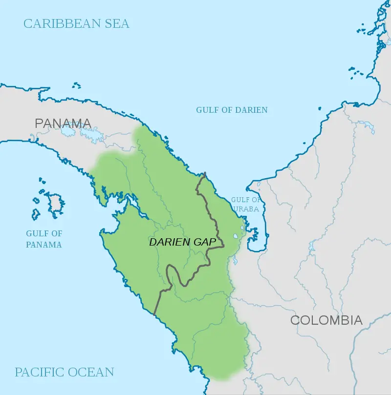
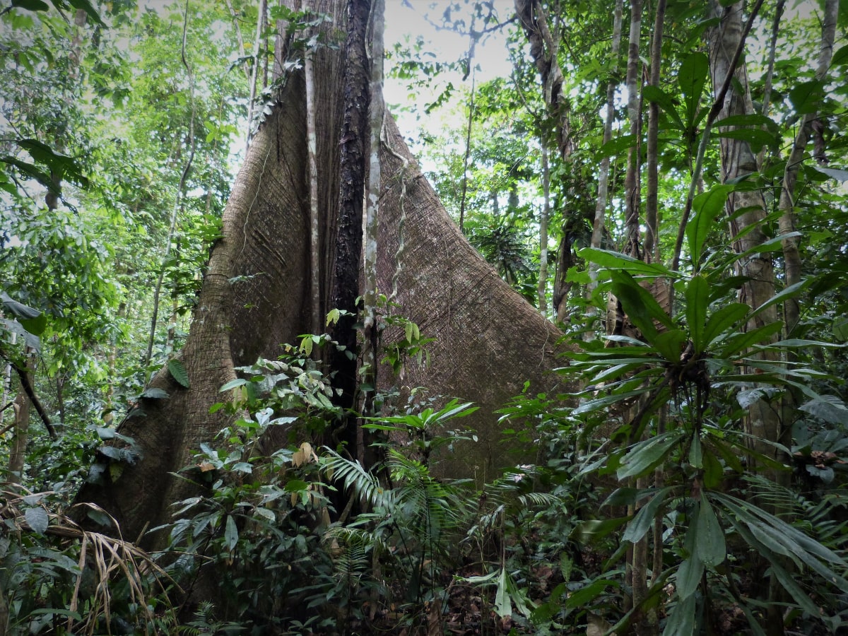
The Darién gap is an 80 km stretch of jungle between Panama and Colombia. Locals mostly know better than to try and cross it, but for anyone looking to combine a South America backpacking route with some travels in Central America, the Darién Gap becomes an important and usually expensive consideration.
A quick look on google maps would suggest that America is one huge continent and it should be possible to travel overland from Alaska, the northernmost state in the USA, right down to the bottom of South America. There is even the so-called Pan-American Highway running from Prudhoe Bay on the freezing northern shores of Alaska right down to Quellón, Chile, and Ushuaia, Argentina.
However there is a problem. As you approach the narrow strip of land where Central America meets South America, the highway stops in the small Panamanian town of Yaviza. It doesn’t start up again until the Colombian town of Turbo. In between, is a dense jungle region of swamps, marshes, and rivers. Plans to connect the two with a road have been met with resistance from environmentalists and would pose great logistical challenges in any case should they ever be approved.
Why is the Darién Gap so dangerous?
The absence of a road hasn’t stopped people from attempting to cross the Darién Gap. However it is a very difficult task, even for those who are extremely fit and have an excellent knowledge of the local area. With the use of local guides, it can be done, but it’s certainly not for the faint-hearted.
Things got even more dangerous in the 1990’s when part of the Darién Gap became a major stronghold for Colombian rebel fighters and armed groups. Travellers and even Panamanian villagers become targets for kidnappings and for a long period, attempting to cross the region was an absolutely crazy thing to even consider.
The 2010’s witnessed a significant de-escalation in the Colombian Conflict which had led to decades of bloodshed across the country. The Darién Gap area became somewhat safer as a result and both adventurists and migrants hoping to make the long voyage to the USA returned.
However as of 2021, the Darién Gap is still home to many, many dangers. It remains something of a lawless wilderness with drug traffickers and bandits known to still be operating in the region. Throw in some dangerous animals including deadly scorpions, spiders and snakes, and the odd unexploded cold war bomb, and it remains a downright dangerous place to attempt to trek through.
Darién Gap Deaths
There are many things that can kill you in the Darién Gap and sadly there are many horror stories of people who have died or disappeared there. Not all of those date back to the 1990’s when Colombia was an incredibly violent place. Recent examples include the 2013 death of Swedish backpacker Jan Philip Braunisch at the hands of FARC rebels.
These days it is Darién Gap migrants who account for most of the deaths in the region. The treacherous nature of the area would make it very difficult to police and it is left almost entirely alone by the Colombian and Panamanian authorities meaning tragically many deaths in the jungle go unrecorded and people who have attempted the crossing in recent years report passing many corpses on the way.
Most of the migrants are from Africa, heading for the United States. They first fly to Ecuador due to its incredibly relaxed visa policy and then travel north via bus through Colombia. Many though are not prepared for the challenges of the jungle. Tired and thirsty, they are easy targets for bandits and thieves on both sides of the unmarked Colombia-Panama border.
How to cross the Darién Gap or get around it!
The Crazy Option
- Trekking Through the Jungle

Deciding to trek through the Darién Gap is probably not the wisest life decision you will ever make. However, if you’re intent on doing so despite the very real risks, it’s highly advisable to try and make use of local guides. The cost of this could well make it the most expensive as well as most dangerous option.
You will also need to do a lot of research into how to pack for the trip and what you should bring. The rivers are dirty and you will need a large amount of clean water. You also need to factor in and take precautions against the risk of malaria which is high and be prepared to be eaten alive by all sorts of insects on the long trek through the jungle which may take over a week.
You can get more information on attempting the crossing in local towns on either side of the border and if you are lucky you may find other mildly insane travellers who are planning to cross the Darién Gap on foot. There are also some tour companies that arrange group crossings of the Darién Gap such as Secret Compass but costs are high and they aren’t running any currently, presumably due to the Covid-19 pandemic.
The Safer Options
- By Boat
As if the situation wasn’t bad enough, there are no public ferries between Panama and Colombia, which is a little bit baffling to be honest with you. For a short period there was a Colon-Cartagena car ferry but it has since been suspended.
Luckily there is no shortage of sailing boats that do the trip and this is probably the most popular option and definitely the most scenic. Most people who have done the trip rave about. It is typically 3 to 5 days and often includes a couple of days stop in the beautifully quiet San Blas Islands.
From Colombia to Panama, it’s best to head to Cartagena and even if you don’t stay there, head to Casa Viena hostel which (at the time of our visit) had a whiteboard with a list of boats doing the trip and remaining spaces on each. Try and talk to the captain of the ship before deciding on one.
Going the other way then Panama City is the best place to arrange the trip (ask in your hostel) and there are normally plenty of boats doing the route every week. It’s worth considering whether food/drinks are included in the price, what extras are included such as diving/snorkeling etc, maybe try and meet your fellow passengers/crew (make sure they’re not going to drive you insane) and also consider whether you suffer from seasickness because you will be spending several days on a fairly small boat.
There are also a few dedicated companies which run boat trips between the two countries with visits to the San Blas Islands. San Blas Adventures for example run a 4-day trip for $445 which includes the transport, food, accommodation on the islands, and snorkelling gear. Other companies run similar trips but you will likely pay more than opting for the sailing boat option.
There are also some cargo ships which do the crossing which may in some cases accept passengers.
- By Air
The good news is that travelling between Colombia and Panama by air has got a lot cheaper in recent years. In the early 2010’s, you could expect to pay several hundred dollars for a flight between the two but you can find flights these days for around $100 or less between Bogota and Panama City.
There are now at least some budget airlines operating in Latin America and that has helped drive down the prices of the bigger airlines too. From Cartagena, if you’re flexible on dates, you can also find the odd direct flight to Panama City for around $100 (excluding baggage fees) with the low-cost airline Wingo.
- By a Combo of Boats & Flights
There is also a hybrid option which is a bit more direct and quicker than the sea crossings and doesn’t result in you missing out on the beauty of the region as would be the case with the commercial flights from a major city such as Bogota, Medellin or Cartagena.
Coming from Central America, you can take a domestic flight from Panama City to the coastal city of Puerto Obaldia just north of the Darién Gap and get your Panamanian exit stamp there. From there you can take a short 30 minute speedboat to Capurgana in Colombia and from there you can change to another boat to Turbo (approx 2 hours 30 minutes). Turbo is located on a major highway with bus links to cities such as Medellin and Cartagena.
Doing the trip in reverse, you could follow the same route. There are also reportedly some flights from Medellin to the town of Acandi, which is only around 20 minutes away by boat from Capurgana. This would significantly cut down on the amount of time spent out on the choppy seas in the area.
Please note, we don’t specifically recommend any company mentioned in this post. They were just ones found during research for updating the article (June 2021). Other, perhaps better options may exist.
This article was fully updated in June 2021.
Hey guys!
For those of you who came across this article while searching for a way from Panama to Colombia or Colombia to Panama, the Darien Gapster has now grown and evolved in to the new and improved San Blas adventures!
We still offer the same thrilling, epic island hopping adventure, however now we are far more established, organised and professional. We offer 5* meals, catering to all dietary restrictions, as well as better accommodation (though still very rustic), a larger fleet of boats owned and operated by the local Kuna people, and a once in a lifetime opportunity to meet and interact with the locals, spending a night in a local village.
we visit uninhabited islands, offer snorkel tours with equipment included, and of course there has to be at least one bonfire party night! We have developed a great balance of culture, environment, party, relaxation and beach time on our trips, so we have something for everyone. We welcome you all to come check it out!
For more information, you can find us here at http://www.sanblasadventures.com
email us at contact@sanblasadventures.com
or get in touch via whatsapp +507 6032 8498
Merchanttraveller.com
I will be travelling on the pacific side end of the year from Colombia and into Panama
If the inland is so dangerous and slow to travel through because of the jungles, then what about the coastline, i.e. the beaches? These might still be prone to the bad people, though there would be less places for them to hide in. Trying to look on Google satellite, it’s hard to tell, but I do see typical sandy beaches. Are there places where the forest comes right up to the ocean (don’t see how there would be no space between the ocean and the brush), or is it cliffs?
good question, don’t know! Can only assume someone would have thought of it were it that simple. I suppose you would also be more exposed on the coast and easy to spot for would-be kidnappers/bad guys. Although supposedly there is now a ceasefire so if that holds, the darien gap land route should become more accessible.
OK, having read even further on it, I was assuming the whole inland way was all “jungle” (rainforest), with maybe a few small rivers, but that’s really mostly the Panama side. This is apparently the easy part, as there are already paths (the ones the natives use, as well as the ones the travellers have cut through).
Most of the Colombia side is the Atrato wetlands, and the river itself, with the western half (running along a perpendicular river that runs into the Atrato) described as a “sunken forest”, and the eastern portion a lower greenery bog described as water filled with “cabbage-like vegetation”, and I guess there are reeds as well. (After that, it finally turns into solid ground, and you start getting little farm roads that connect to the PanAmerican Hwy in or near the town of Chigorodo).
This wetland would obviously be worse where it opens out into the sea, so the coastline option is out, and this seems to be a big barrier on the inland route as well. It seems all of the people “driving” or “walking” through have had to ride or load their vehicles on to a canoe or boat at least part of the way. (I saw a rumor of a dirt road being cut all the way through, but I don’t see how it would gets over the wetlands and the river). If they ever build the highway through, they would need a 30 mile causeway through that part, or tunnels.
Small airline ADA fly direct Medellin – Acandi then boat trip (20 minutes) to Capurgana etc. (No more direct flights to Capurgana).
Land route now more dangerous than ever, see my blog for recent info and sad case of traveller killed by armed group trying to cross Colombia – Panama http://travelswithmitzi.blogspot.com/2015/07/lost-in-darien-gap.html